Page History
| Excerpt | ||
|---|---|---|
| ||
| Panel | ||||||
|---|---|---|---|---|---|---|
| ||||||
On this page... |
Component Overview
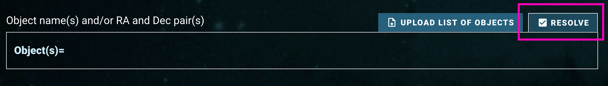
This page describes the Cone Search and Upload List area. These components are used for searches that are based on coordinates (positions) on the sky (also known as cone searches), or based on an uploaded list of target information, such as resolvable object names, coordinates, or dataset IDs. A Cone Search is performed when the "Resolve" toggle button  is checked (selected):
If a search by exact match on Target Name is preferred, please refer to the Target Name Search documentation.
Component Features and Functionality
A description of the Cone Search and Upload List Component capabilities: Search By Object Names To Resolve Into Coordinates, Search By Coordinates, Upload A List, and Specify The Cone Search Radius.
| Info |
|---|
|
| Panel | ||||||
|---|---|---|---|---|---|---|
| ||||||
|
| Panel | ||||||
|---|---|---|---|---|---|---|
| ||||||
One or more object names can be entered into the 'Object Search' box. Press 'tab', 'return', or 'comma' on your keyboard to finish entering the object name (clicking off the text box will also work). The form will attempt to resolve the object name into a coordinate using the MAST name resolving service. This service looks up the object's name using Simbad, NED, and several databases internal to MAST.

|

| Panel | ||||||
|---|---|---|---|---|---|---|
| ||||||
|


| Panel | ||||||||||||
|---|---|---|---|---|---|---|---|---|---|---|---|---|
| ||||||||||||
|
| Panel | |||||||||||||
|---|---|---|---|---|---|---|---|---|---|---|---|---|---|
| |||||||||||||
One or more coordinates can be entered into the 'Object Search' box. Coordinates can be entered in sexagesimal notation (Right Ascension in hours; HH MM SS.ss or HH:MM:SS.ss, Declination in degrees; DD MM SS.ss or DD:MM:SS.ss) or in decimal notation (Right Ascension and Declination both in degrees; DDD.dd). Press 'tab', 'return', or 'comma' on your keyboard to finish entering the coordinate (clicking off the text box will also work).
|


| Panel | ||||||
|---|---|---|---|---|---|---|
| ||||||
|
| Panel | ||||||||||||||||||||||||||
|---|---|---|---|---|---|---|---|---|---|---|---|---|---|---|---|---|---|---|---|---|---|---|---|---|---|---|
| ||||||||||||||||||||||||||
Since there are a wide variety of ways to upload lists of objects, a number of sample files is provided in the table below.
|
| Panel | ||||||||||
|---|---|---|---|---|---|---|---|---|---|---|
| ||||||||||
A file can be uploaded into the form that contains a list of object names to resolve into coordinates, coordinate pairs of Right Ascension and Declination, or Dataset IDs. The file must be in comma-separated value (CSV) format, and the top row must contain a header with column names. The header row does not need any special character in the front: the first row is always read in as the header row. The header row is case-insensitive.
The number of object names that were successfully and unsuccessfully resolved is reported, and clicking on the number of unsuccessful name resolves will display an overlay with more information and line numbers to provide further information. The columns in the uploaded file are included in the search results table on the far right, with labels of 'User File <col>'. For example, if the uploaded file contained rows labeled 'target', 'ra', 'dec', 'dataset_id' they are included in the search results table as 'User File target', 'User File ra', 'User File dec', and 'User File dataset_id'.
|
| Panel | ||||||
|---|---|---|---|---|---|---|
| ||||||
|
| Panel | ||||||||
|---|---|---|---|---|---|---|---|---|
| ||||||||
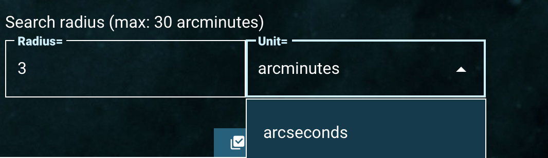
Regardless of how a position on the sky is specified (through an object name resolved into coordinates, or directly using Right Ascension and Declination) the size of the search radius is defined using the 'Search Radius' component. The radius may be defined in either arcseconds or arcminutes. The default size is 3 arcminutes in the form and a maximum radius of 30 arcminutes is allowed. If a list is uploaded to the search form, this cone search radius is applied to every object name or coordinate in that list.
|
For Further Reading...
| Excerpt | ||
|---|---|---|
| ||
| Panel | ||||||
|---|---|---|---|---|---|---|
| ||||||
On this page... |
Component Overview
This page describes the Cone Search and Upload List area. These components are used for searches that are based on coordinates (positions) on the sky (also known as cone searches), or based on an uploaded list of target information, such as resolvable object names, coordinates, or dataset IDs.
Component Features and Functionality
A description of the Cone Search and Upload List Component capabilities: Search By Object Names To Resolve Into Coordinates, Search By Coordinates, Upload A List, and Specify The Cone Search Radius.
| Info |
|---|
|
| Panel | ||||||
|---|---|---|---|---|---|---|
| ||||||
|
| Panel | ||||||
|---|---|---|---|---|---|---|
| ||||||
One or more object names can be entered into the 'Object Search' box. Press 'tab', 'return', or 'comma' on your keyboard to finish entering the object name (clicking off the text box will also work). The form will attempt to resolve the object name into a coordinate using the MAST name resolving service. This service looks up the object's name using Simbad, NED, and several databases internal to MAST.
|
| Panel | ||||||
|---|---|---|---|---|---|---|
| ||||||
|
| Panel | ||||||
|---|---|---|---|---|---|---|
| ||||||
|
| Panel | |||||||||||||
|---|---|---|---|---|---|---|---|---|---|---|---|---|---|
| |||||||||||||
One or more coordinates can be entered into the 'Object Search' box. Coordinates can be entered in sexagesimal notation (Right Ascension in hours; HH MM SS.ss or HH:MM:SS.ss, Declination in degrees; DD MM SS.ss or DD:MM:SS.ss) or in decimal notation (Right Ascension and Declination both in degrees; DDD.dd). Press 'tab', 'return', or 'comma' on your keyboard to finish entering the coordinate (clicking off the text box will also work).
|
| Panel | ||||||
|---|---|---|---|---|---|---|
| ||||||
|
| Panel | ||||||||||||||||||||||||||
|---|---|---|---|---|---|---|---|---|---|---|---|---|---|---|---|---|---|---|---|---|---|---|---|---|---|---|
| ||||||||||||||||||||||||||
Since there are a wide variety of ways to upload lists of objects, a number of sample files is provided in the table below.
|
| Panel | ||||||||||
|---|---|---|---|---|---|---|---|---|---|---|
| ||||||||||
A file can be uploaded into the form that contains a list of object names to resolve into coordinates, coordinate pairs of Right Ascension and Declination, or Dataset IDs. The file must be in comma-separated value (CSV) format, and the top row must contain a header with column names. The header row does not need any special character in the front: the first row is always read in as the header row. The header row is case-insensitive.
The number of object names that were successfully and unsuccessfully resolved is reported, and clicking on the number of unsuccessful name resolves will display an overlay with more information and line numbers to provide further information. The columns in the uploaded file are included in the search results table on the far right, with labels of 'User File <col>'. For example, if the uploaded file contained rows labeled 'target', 'ra', 'dec', 'dataset_id' they are included in the search results table as 'User File target', 'User File ra', 'User File dec', and 'User File dataset_id'.
|
| Panel | ||||||
|---|---|---|---|---|---|---|
| ||||||
|
| Panel | ||||||||
|---|---|---|---|---|---|---|---|---|
| ||||||||
Regardless of how a position on the sky is specified (through an object name resolved into coordinates, or directly using Right Ascension and Declination) the size of the search radius is defined using the 'Search Radius' component. The radius may be defined in either arcseconds or arcminutes. The default size is 3 arcminutes in the form and a maximum radius of 30 arcminutes is allowed. If a list is uploaded to the search form, this cone search radius is applied to every object name or coordinate in that list.
|