| Panel |
|---|
| borderColor | #00617E |
|---|
| borderWidth | 2px |
|---|
| borderStyle | solid |
|---|
|
On this page... |
Component Overview
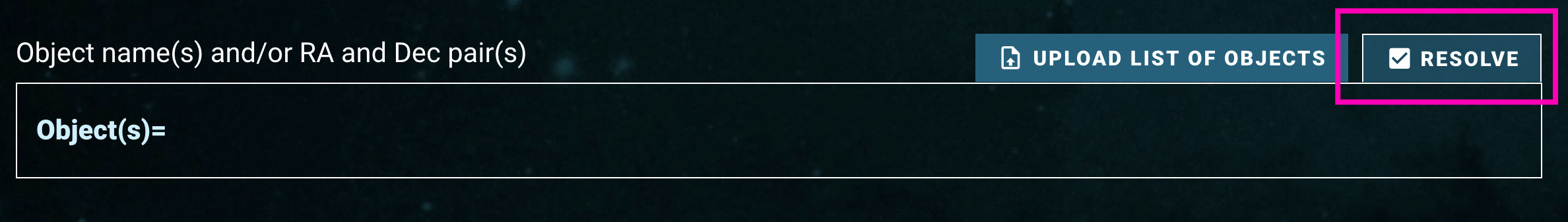
This page describes the Cone Search and Upload List area. These components are used for searches that are based on coordinates (positions) on the sky (also known as cone searches), or based on an uploaded list of target information, such as resolvable object names, coordinates, or dataset IDs. A Cone Search is performed when the "Resolve" toggle button  is checked (selected):
If a search by exact match on Target Name is preferred, please refer to the Target Name Search documentation.
Component Features and Functionality
A description of the Cone Search and Upload List Component capabilities: Search By Object Names To Resolve Into Coordinates, Search By Coordinates, Upload A List, and Specify The Cone Search Radius.
| Info |
|---|
- Any combination of object names and/or coordinates (see below) can be entered using this component, it can resolve either one as they are entered!
- Enabling a search does not require specifying a coordinate or object name. Use the search form to conduct a search based only on other search parameters, or even no parameters at all! Searching with nothing entered in the form retrieves all available entries from a given data collections.
|
| Panel |
|---|
| borderColor | #00617E |
|---|
| bgColor | #E3EEF1 |
|---|
| borderWidth | 2 |
|---|
|
| Widget Connector |
|---|
| width | 100% |
|---|
| url | https://www.youtube.com/watch?v=4jGcq51T574NGtEZoiEHoM&list=PLCPZgcYzVpj8qY0djk73Bp3QU8W9HMGIv&index=2 |
|---|
|
|
| Panel |
|---|
| borderColor | #00617E |
|---|
| bgColor | #E3EEF1 |
|---|
| borderWidth | 2 |
|---|
|
| Anchor |
|---|
| single_target |
|---|
| single_target |
|---|
|
Search By Object Names To Resolve Into CoordinatesOne or more object names can be entered into the 'Object Search' box. Press 'tab', 'return', or 'comma' on your keyboard to finish entering the object name (clicking off the text box will also work). The form will attempt to resolve the object name into a coordinate using the MAST name resolving service. This service looks up the object's name using Simbad, NED, and several databases internal to MAST. - Upon a successful resolve, the object name will be surrounded by a green color, a check mark is added in front of the name, and the resolved coordinate will appear to the right of the object name in parenthesis. The coordinate shown will be used as the center of the cone search for that object.
 Image Modified Image Modified- If the object name can not be resolved, the target will be surrounded by a yellow color and an exclamation point is added in front of the name.
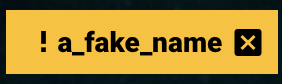 Image Modified Image Modified - The 'X' mark right next to each entry can used to remove an object.
|
| Panel |
|---|
| borderColor | #00617E |
|---|
| bgColor | #E3EEF1 |
|---|
| borderWidth | 2 |
|---|
|
| Widget Connector |
|---|
| width | 100% |
|---|
| url | https://www.youtube.com/watch?v=EbH7YP634S0 |
|---|
| | Widget Connector |
|---|
| width | 100% |
|---|
| url | https://youtu.be/HxIogL3vaFQuJDFNfQsbLU |
|---|
|
|
| Panel |
|---|
| borderColor | #00617E |
|---|
| bgColor | #E3EEF1 |
|---|
| borderWidth | 2 |
|---|
|
| Search By Coordinates One or more coordinates can be entered into the 'Object Search' box. Coordinates can be entered in sexagesimal notation (Right Ascension in hours; HH MM SS.ss or HH:MM:SS.ss, Declination in degrees; DD MM SS.ss or DD:MM:SS.ss) or in decimal notation (Right Ascension and Declination both in degrees; DDD.dd). Press 'tab', 'return', or 'comma' on your keyboard to finish entering the coordinate (clicking off the text box will also work). | Note |
|---|
| title | Values outside the bounds |
|---|
| Right Ascension values outside the bounds of 0.0 <= R.A. <= 360.0 degrees will be wrapped to fit with these bounds. 
Declination values outside the bounds of -90.0 <= Dec. <= 90.0 will be parsed as invalid. 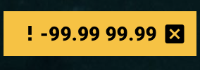
For positive values, you may optionally decide to include a '+' sign. |
| Warning |
|---|
When entering a coordinate, do not include a comma or semicolon between R.A. and Dec. Separate them with only a space. |
|
| Panel |
|---|
| borderColor | #00617E |
|---|
| bgColor | #E3EEF1 |
|---|
| borderWidth | 2 |
|---|
|
| Widget Connector |
|---|
| width | 100% |
|---|
| url | https://www.youtube.com/watch?v=hLaloMVMT9g |
|---|
|
|
| Panel |
|---|
| borderColor | #00617E |
|---|
| bgColor | #E3EEF1 |
|---|
| borderWidth | 2 |
|---|
|
Since there are a wide variety of ways to upload lists of objects, a number of sample files is provided in the table below. | Divbox |
|---|
| style | background-color:white;margin:0px;border:0px; |
|---|
| | Panel |
|---|
| borderColor | black |
|---|
| title | CSV File Format Example |
|---|
| target,ra,dec,dataset_id
M101, 14:03:12.545, +54:20:56.22, J8OB02011
51 Peg, 22 57 27.960, +20 46 07.75, O4ZE04020
TRAPPIST-1,23h06m29.368s,-05h02m29.03s, ID4301QPQ
helix nebula, 22:29:38.545, -20:50:13.75, W1KA2T01T |
|
| Description | Sample Upload File |
|---|
| One column, only object names. | | | One column, only coordinates. | | | One column, only dataset IDs. | | | Three columns, object names and coordinates. | example_idandcoords.csv | | Four columns, object names, coordinates, and dataset IDs. | example_idandcoordsanddatasets.csv | | Five columns, object names, coordinates, and two user-defined columns. | example_idandcoordsandnotes.csv |
|
| Panel |
|---|
| borderColor | #00617E |
|---|
| bgColor | #E3EEF1 |
|---|
| borderWidth | 2 |
|---|
|
| Upload A List Of Object Names To Resolve Into Coordinates, Cone Search Coordinates, or Dataset IDs A file can be uploaded into the form that contains a list of object names to resolve into coordinates, coordinate pairs of Right Ascension and Declination, or Dataset IDs. The file must be in comma-separated value (CSV) format, and the top row must contain a header with column names. The header row does not need any special character in the front: the first row is always read in as the header row. The header row is case-insensitive. | Warning |
|---|
The uploaded file must contain at least one of three search parameters: object name (using the header "Target"), coordinate (using the headers "RA" and "Dec"), and/or dataset ID (using the header "Dataset_ID"). Remember that the headers are case-insensitive ("dataset_id" works as well as "Dataset_ID").) |
- If the file contains object names, coordinates, and dataset IDs, the search form will use the dataset IDs and return those exact matches in the search results.
- If the file contains object names and coordinates, the search form will use the coordinates to perform cone searches, and it will not attempt to resolve any object names.
- If the file contains only object names, the search form will attempt to resolve them into coordinates.
The number of object names that were successfully and unsuccessfully resolved is reported, and clicking on the number of unsuccessful name resolves will display an overlay with more information and line numbers to provide further information. The columns in the uploaded file are included in the search results table on the far right, with labels of 'User File <col>'. For example, if the uploaded file contained rows labeled 'target', 'ra', 'dec', 'dataset_id' they are included in the search results table as 'User File target', 'User File ra', 'User File dec', and 'User File dataset_id'. | Info |
|---|
If there are additional columns in the uploaded CSV file, they will be included in the search result table in the far right as well. This allows additional columns to be cross-matched to the search results and thus included when exporting the search result table. |
|
| Panel |
|---|
| borderColor | #00617E |
|---|
| bgColor | #E3EEF1 |
|---|
| borderWidth | 2 |
|---|
|
|
| Panel |
|---|
| borderColor | #00617E |
|---|
| bgColor | #E3EEF1 |
|---|
| borderWidth | 2 |
|---|
|
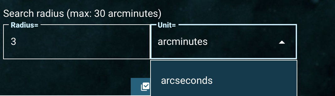
| Specifying The Cone Search Radius Regardless of how a position on the sky is specified (through an object name resolved into coordinates, or directly using Right Ascension and Declination) the size of the search radius is defined using the 'Search Radius' component. The radius may be defined in either arcseconds or arcminutes. The default size is 3 arcminutes in the form and a maximum radius of 30 arcminutes is allowed. If a list is uploaded to the search form, this cone search radius is applied to every object name or coordinate in that list. | Note |
|---|
If a list of Dataset IDs is specified, a cone search is not conducted; thus this component is not used. Instead, a direct match on the dataset IDs is performed. |
|
| Panel |
|---|
| borderColor | #00617E |
|---|
| bgColor | #E3EEF1 |
|---|
| borderWidth | 2 |
|---|
|
| Widget Connector |
|---|
| width | 100% |
|---|
| url | https://www.youtube.com/watch?v=hLaloMVMT9g |
|---|
|
|
| Panel |
|---|
| borderColor | #00617E |
|---|
| bgColor | #E3EEF1 |
|---|
| borderWidth | 2 |
|---|
|
Since there are a wide variety of ways to upload lists of objects, a number of sample files is provided in the table below.
| Divbox |
|---|
| style | background-color:white;margin:0px;border:0px; |
|---|
|
| Panel |
|---|
| borderColor | black |
|---|
| title | CSV File Format Example |
|---|
|
target,ra,dec,dataset_id
M101, 14:03:12.545, +54:20:56.22, J8OB02011
51 Peg, 22 57 27.960, +20 46 07.75, O4ZE04020
TRAPPIST-1,23h06m29.368s,-05h02m29.03s, ID4301QPQ
helix nebula, 22:29:38.545, -20:50:13.75, W1KA2T01T |
| Description | Sample Upload File |
|---|
| One column, only object names. | |
| One column, only coordinates. | |
| One column, only dataset IDs. | |
| Three columns, object names and coordinates. | example_idandcoords.csv |
| Four columns, object names, coordinates, and dataset IDs. | example_idandcoordsanddatasets.csv |
| Five columns, object names, coordinates, and two user-defined columns. | example_idandcoordsandnotes.csv |
| Panel |
|---|
| borderColor | #00617E |
|---|
| bgColor | #E3EEF1 |
|---|
| borderWidth | 2 |
|---|
|
| Anchor |
|---|
upload_list | upload_list | For Further Reading...
| Excerpt |
|---|
|
| Panel |
|---|
| borderColor | #00617E |
|---|
| borderWidth | 2px |
|---|
| borderStyle | solid |
|---|
|
On this page... |
Component Overview
This page describes the Cone Search and Upload List area. These components are used for searches that are based on coordinates (positions) on the sky (also known as cone searches), or based on an uploaded list of target information, such as resolvable object names, coordinates, or dataset IDs.
Component Features and Functionality
A description of the Cone Search and Upload List Component capabilities: Search By Object Names To Resolve Into Coordinates, Search By Coordinates, Upload A List, and Specify The Cone Search Radius.
| Info |
|---|
- Any combination of object names and/or coordinates (see below) can be entered using this component, it can resolve either one as they are entered!
- Enabling a search does not require specifying a coordinate or object name. Use the search form to conduct a search based only on other search parameters, or even no parameters at all! Searching with nothing entered in the form retrieves all available entries from a given data collections.
|
| Panel |
|---|
| borderColor | #00617E |
|---|
| bgColor | #E3EEF1 |
|---|
| borderWidth | 2 |
|---|
|
| Widget Connector |
|---|
| width | 100% |
|---|
| url | https://www.youtube.com/watch?v=4jGcq51T574 |
|---|
|
|
| Panel |
|---|
| borderColor | #00617E |
|---|
| bgColor | #E3EEF1 |
|---|
| borderWidth | 2 |
|---|
|
| Anchor |
|---|
single_target | single_target | Search By Object Names To Resolve Into CoordinatesOne or more object names can be entered into the 'Object Search' box. Press 'tab', 'return', or 'comma' on your keyboard to finish entering the object name (clicking off the text box will also work). The form will attempt to resolve the object name into a coordinate using the MAST name resolving service. This service looks up the object's name using Simbad, NED, and several databases internal to MAST.
- Upon a successful resolve, the object name will be surrounded by a green color, a check mark is added in front of the name, and the resolved coordinate will appear to the right of the object name in parenthesis. The coordinate shown will be used as the center of the cone search for that object.
Image Removed- If the object name can not be resolved, the target will be surrounded by a yellow color and an exclamation point is added in front of the name.
Image Removed
- The 'X' mark right next to each entry can used to remove an object.
| Panel |
|---|
| borderColor | #00617E |
|---|
| bgColor | #E3EEF1 |
|---|
| borderWidth | 2 |
|---|
|
| Widget Connector |
|---|
| width | 100% |
|---|
| url | https://www.youtube.com/watch?v=EbH7YP634S0 |
|---|
|
|
| Panel |
|---|
| borderColor | #00617E |
|---|
| bgColor | #E3EEF1 |
|---|
| borderWidth | 2 |
|---|
|
| Anchor |
|---|
single_coord | single_coord | Search By CoordinatesOne or more coordinates can be entered into the 'Object Search' box. Coordinates can be entered in sexagesimal notation (Right Ascension in hours; HH MM SS.ss or HH:MM:SS.ss, Declination in degrees; DD MM SS.ss or DD:MM:SS.ss) or in decimal notation (Right Ascension and Declination both in degrees; DDD.dd). Press 'tab', 'return', or 'comma' on your keyboard to finish entering the coordinate (clicking off the text box will also work).
| Note |
|---|
| title | Values outside the bounds |
|---|
|
Right Ascension values outside the bounds of 0.0 <= R.A. <= 360.0 degrees will be wrapped to fit with these bounds. Image Removed Declination values outside the bounds of -90.0 <= Dec. <= 90.0 will be parsed as invalid. Image Removed For positive values, you may optionally decide to include a '+' sign. |
| Warning |
|---|
When entering a coordinate, do not include a comma or semicolon between R.A. and Dec. Separate them with only a space. |
A Of Object Names To Resolve Into Coordinates, Cone Coordinates, or Dataset IDsA file can be uploaded into the form that contains a list of object names to resolve into coordinates, coordinate pairs of Right Ascension and Declination, or Dataset IDs. The file must be in comma-separated value (CSV) format, and the top row must contain a header with column names. The header row does not need any special character in the front: the first row is always read in as the header row. The header row is case-insensitive.
| Warning |
|---|
The uploaded file must contain at least one of three search parameters: object name (using the header "Target"), coordinate (using the headers "RA" and "Dec"), and/or dataset ID (using the header "Dataset_ID"). Remember that the headers are case-insensitive. |
- If the file contains object names, coordinates, and dataset IDs, the search form will use the dataset IDs and return those exact matches in the search results.
- If the file contains object names and coordinates, the search form will use the coordinates to perform cone searches, and it will not attempt to resolve any object names.
- If the file contains only object names, the search form will attempt to resolve them into coordinates.
The number of object names that were successfully and unsuccessfully resolved is reported, and clicking on the number of unsuccessful name resolves will display an overlay with more information and line numbers to provide further information.
The columns in the uploaded file are included in the search results table on the far right, with labels of 'User File <col>'. For example, if the uploaded file contained rows labeled 'target', 'ra', 'dec', 'dataset_id' they are included in the search results table as 'User File target', 'User File ra', 'User File dec', and 'User File dataset_id'.
| Info |
|---|
If there are additional columns in the uploaded CSV file, they will be included in the search result table in the far right as well. This allows additional columns to be cross-matched to the search results and thus included when exporting the search result table. |
| Panel |
|---|
| borderColor | #00617E |
|---|
| bgColor | #E3EEF1 |
|---|
| borderWidth | 2 |
|---|
|
Image Removed |
| Panel |
|---|
| borderColor | #00617E |
|---|
| bgColor | #E3EEF1 |
|---|
| borderWidth | 2 |
|---|
|
| Anchor |
|---|
cone_size | cone_size | Specifying The Cone Search RadiusRegardless of how a position on the sky is specified (through an object name resolved into coordinates, or directly using Right Ascension and Declination) the size of the search radius is defined using the 'Search Radius' component. The radius may be defined in either arcseconds or arcminutes. The default size is 3 arcminutes in the form and a maximum radius of 30 arcminutes is allowed.
If a list is uploaded to the search form, this cone search radius is applied to every object name or coordinate in that list.
| Note |
|---|
If a list of Dataset IDs is specified, a cone search is not conducted; thus this component is not used. Instead, a direct match on the dataset IDs is performed. |


